RTOPO 3.1 Details
Shareware 1012 KB
Publisher Description
 Simple, powerful and inexpensive CAD software for surveying. You can do triangulation, isolines, color-filled contour maps, sections, intersections, volume and much more. You can process hundreds of thousands of points or triangles, even on less powerful PCs.
Through its own CAD system (called RCAD), specialized for 3D and for a large number of entities, you can:
-load and draw a file of points having the format: Number X Y Z Code; the drawing is made by POINT,3DPOLY,SPLINE or BLOCK entities, according to a modifiable library of codes
-edit interactively the points; you can modify the coordinates, the code and the position (in 3DPOLY or SPLINE)
-triangulate the points on a convex hull or between an external contour and possibly more interior contours
-do isolines (contour lines) and color-filled contour map
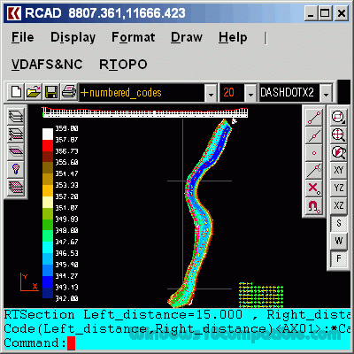
-do cross sections and longitudinal profile
-do the projection of several PLine entities over a triangulation
-do the conversion of a triangulation to a regular grid of points
-do the conversion of the existing isolines resulting from maps in points and then in a triangulation
-represent the geological_stratification resulting from drilling
-calculate 3D area, center of gravity and the volume between 2 triangulations or between a triangulation and a plan
-intersect and divide two triangulations (or two sets of 3dmesh and 3dface entities) or a triangulation by a horizontal plan
-interpolate a set of 3DFACE entities, using quartic triangular patches (G1 continuity)
-transform a drawing containing entities as PLine, Line, Block and Text, in points having codes and then in a triangulation,
-represent 4D points cloud.
RCAD CAD system, distributed together with RTOPO, provides OpenGL real-time orbit, pan,zoom, shading, lighting and motion path animation. RCAD is similar with other popular CAD systems and can load and save DXF files. It has entries in the command text area, graphics area, menus and toolbars and can run scripts.
Simple, powerful and inexpensive CAD software for surveying. You can do triangulation, isolines, color-filled contour maps, sections, intersections, volume and much more. You can process hundreds of thousands of points or triangles, even on less powerful PCs.
Through its own CAD system (called RCAD), specialized for 3D and for a large number of entities, you can:
-load and draw a file of points having the format: Number X Y Z Code; the drawing is made by POINT,3DPOLY,SPLINE or BLOCK entities, according to a modifiable library of codes
-edit interactively the points; you can modify the coordinates, the code and the position (in 3DPOLY or SPLINE)
-triangulate the points on a convex hull or between an external contour and possibly more interior contours
-do isolines (contour lines) and color-filled contour map
-do cross sections and longitudinal profile
-do the projection of several PLine entities over a triangulation
-do the conversion of a triangulation to a regular grid of points
-do the conversion of the existing isolines resulting from maps in points and then in a triangulation
-represent the geological_stratification resulting from drilling
-calculate 3D area, center of gravity and the volume between 2 triangulations or between a triangulation and a plan
-intersect and divide two triangulations (or two sets of 3dmesh and 3dface entities) or a triangulation by a horizontal plan
-interpolate a set of 3DFACE entities, using quartic triangular patches (G1 continuity)
-transform a drawing containing entities as PLine, Line, Block and Text, in points having codes and then in a triangulation,
-represent 4D points cloud.
RCAD CAD system, distributed together with RTOPO, provides OpenGL real-time orbit, pan,zoom, shading, lighting and motion path animation. RCAD is similar with other popular CAD systems and can load and save DXF files. It has entries in the command text area, graphics area, menus and toolbars and can run scripts.
Download and use it now: RTOPO
Related Programs
TRIANGULATION for IntelliCAD
TRIANGULATION, ISOLINES, VOLUME, LOADING of XYZ points files, 3DINTERSECTION, cross sections and a longitudinal profile, color-filled contour map; 7 functions for IntelliCAD versions which can load SDS applications (dll). TRIANGULATION performs the triangulation of a set of 3D points with...
- Shareware
- 20 Jul 2015
- 587 KB
TRIANGULATION for AutoCAD
An application for AUTOCAD 2002-2016 or ZWCAD 2014-2015, which makes the triangulation of a set of POINT entities, the intersection curves (isolines) between a set of 3DFACE entities and a set of equidistance plans, horizontally or vertically and the volume...
- Shareware
- 20 Jul 2015
- 577 KB
AEC Terrain
Introducing you AEC Terrain interface which is designed to simplify terrain management and 3D-modeling. AEC Terrain creates Digital Elevation Model from multiple input point files on AutoCAD graphic editor. All purpose multi-level pads, road alignments, mining applications and airfields can...
- Shareware
- 20 Jul 2015
- 16.33 MB
ESurvey Sections
"ESurvey Sections" is a complete Section Creation and Management Solution designed to help engineers, surveyors and designers to create industry standard drawings and to generate instant calculation reports related to Road / Railway lines / Irrigation / Pipeline design /...
- Shareware
- 20 Jul 2015
- 28.97 MB
English Irregular Verbs with Music
English Irregular Verbs with Music is a teaching karaoke-program. Karaoke type exercises guarantee 100% memorization! You'll remember the verbs as well as the lyrics of your favourite song! English Irregular Verbs with Music is the undoubtedly unique program that has...
- Demo
- 20 Jul 2015
- 91.18 MB